
Updated October 4th, 2026
Dear Members and Neighbors,
Smart Growth 41 and the Park West Master Association have jointly filed a legal challenge to the South Carolina Department of Environmental Services’ approval of the Highway 41 project. This filing marks the next step in our continuing effort to protect Laurel Hill County Park, surrounding neighborhoods and the waterways on which our communities depend.
We know the state’s decision to issue the permit was disappointing to many of you. We share that disappointment. But our commitment to pushing for a better road design has not changed, and we have not given up. We are now bringing our concerns before the South Carolina Administrative Law Court and seeking review of the agency’s decision.
The challenge centers on whether SCDES adequately evaluated and addressed the project’s effects on flooding, drainage, wetlands and water quality before issuing its permit. These concerns have practical consequences for residents: how stormwater moves through our neighborhoods, what happens when wetlands that store floodwater are filled, and whether our creeks and rivers will receive adequate protection. Our filing asks the court to require those concerns to be properly addressed before the approval can stand.
The project also still requires a separate federal permit from the U.S. Army Corps of Engineers. As far as how this impacts project timing, this legal challenge could delay a Corps permitting decision. Charleston County also cannot begin construction that requires state approval while the permit remains stayed. If successful, the lawsuit could overturn the state approval and stop the project from proceeding in its current form altogether. While we cannot guarantee the timing or result, we will continue monitoring the permitting process closely and fighting to stop this flawed project where opportunities arise.
This next phase will take time. Some of the early work will involve court procedures and obtaining and reviewing the records behind the state’s decision. There may be periods when there is little new information to report publicly, but work will continue. We will keep you informed as meaningful developments occur.
Thank you to everyone who has attended meetings, submitted comments, shared concerns and supported this effort. Your participation has helped build the foundation for this challenge and continues to strengthen our resolve.
We may also assemble a legal committee to help support our efforts as the litigation progresses. Please keep an eye out for future announcements and opportunities to participate.
Our goal remains the same: advocating for the best transportation solution for the Highway 41 expansion. The fight continues, and we remain committed to seeing it through.
Sincerely,
Smart Growth 41
Park West Master Association
Smart Growth 41 is a coalition of Local Highway 41 citizens
working to advance the best transportation solution for the Highway 41 expansion in Charleston County.
Our Primary Concerns are with
Identifying The Best Travel Solution
The “Road to Compromise” proposal does not address traffic in the neighborhoods it plans to bisect. It also is a poor solution considering the estimated 18,000 home units being built in Berkley County which will use Highway 41.
Child & Pedestrian Safety
The “Road to Compromise” proposal poses a safety risk by routing highway traffic into neighborhood streets and posing a safety risk to pedestrians and cyclists.
Severe Environmental Loss
A massive area of forest and marshland will be lost forever if the “Road to Compromise” is built.
Cost to The Taxpayer
"The Road to Compromise" will cost $23 million more than what was originally budgeted for Highway 41 expansion. This shortfall will likely need to be covered by higher taxes or by redirecting funds from other County transportation projects.
The Facts
The “Road to Compromise” proposal would be $23 million more expensive than what was originally budgeted for this project, more adversely affect the surrounding environment, and fail to address the future growth needs of our region.
The Facts
The “Road to Compromise” proposal would be $23 million more expensive than what was originally budgeted for this project, more adversely affect the surrounding environment, and fail to address the future growth needs of our region.
For over five years Charleston County has been working to identify a solution to alleviate the current and worsening traffic problems on Highway 41. After an extensive study period it was determined that Alternative 1, widening the existing Highway 41 right-of-way, was the most practical and effective transportation solution to alleviate area traffic issues and accommodate future growth in the region. It would accomplish this goal at the lowest cost to the taxpayer and with the smallest environmental impact.
Along the way several misconceptions developed regarding the preferred Alternative 1 solution. Charleston County is now in the process of revisiting a modified version of the previously rejected Alternative 7 proposal to widen Highway 41. Colloquially known as the “Road to Compromise”, it would be $23 million more expensive than what was originally budgeted for this project, more adversely affect the surrounding environment, and fail to address the future growth needs of our region.
Smart Growth 41 was created to dispel this confusion surrounding the expansion of Highway 41 and to find the solution that would have the lowest cost and greatest benefit to Charleston County. At the start of this process several evaluation criteria were established to determine which proposed expansion of Highway 41 would best meet the project need. The leadership of Charleston County should lean on this scorecard and adopt a facts-based approach when determining their final design for this project.
Environmental Impact
Environmental Impact
The "Road to Compromise" will destroy a large section of park forest, disrupting wildlife permanently.
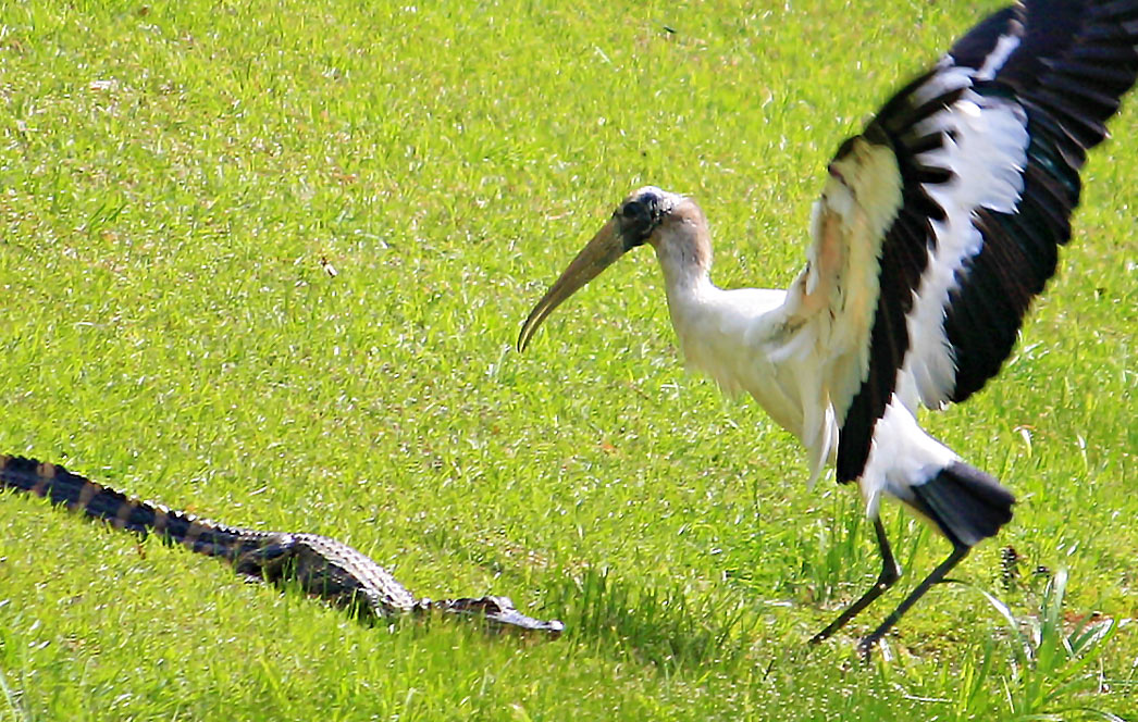
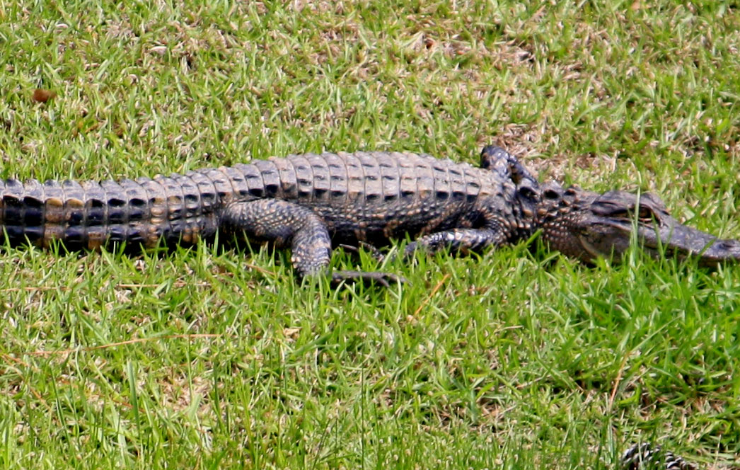
Hawks, Alligators, Turkey, Deer, Ducks, Cranes, Heron, Coyotes, Wild Cats, and more will lose their territory and very likely their ability to survive.
These photos were taken of wildlife living in the forest that would be impacted by the new highway



The below drone footage shows the area of Charleston county forest that will be destroyed for The "Road to compromise".
In fact, our drone range wasn't far enough to show the entire path of deforestation.
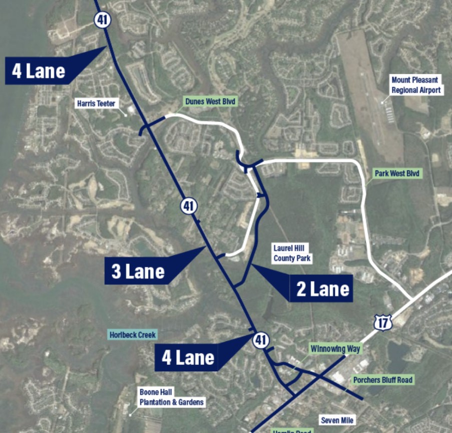
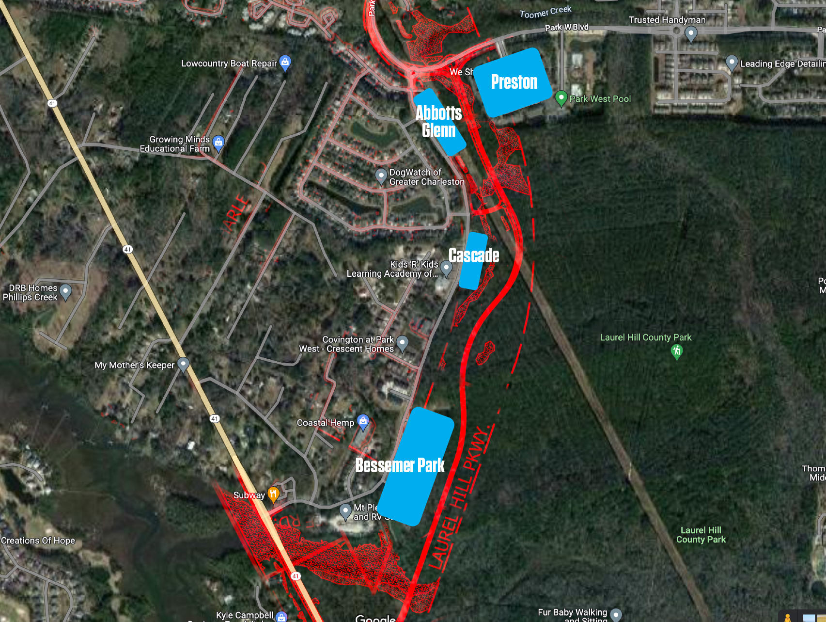
The map below shows the new Laurel Hill Parkway path through the
forest wetlands and skirting neighborhoods in Park West.
Child and Pedestrian Safety
Child & Pedestrian Safety
The “Road to Compomise” will route highway traffic through a congested pedestrian area with walkers, joggers, bicyclists, and young children that has previously experienced tragic accidents. Dramatically increasing the number of vehicles driving through this area will greatly increase the potential and probability for more accidents involving pedestrians.
School Children Hit by Cars
The proposed extension splits 2 neighborhoods, and will force families to regularly cross a four lane highway to access public schools, child care, parks, and amenities, causing a safety hazard.
In Park West alone, there have been 2 publicized accidents where children using the crosswalk have been hit by a vehicle, despite numerous safety measures such as a crossing guard and flashing warning lights.
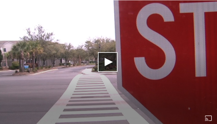
“All of the cars had stopped on both sides and then when she started to go out, this truck just came around from nowhere and hit her,” said Rogge. “When the truck hit her, her whole body went flying over to that side in the air. She had a fractured skull and she had road rash all over her, she had stitches all up in her mouth, she was in the hospital for three days”
Increased Traffic Volume equals higher rates of pedestrian incidents
Rerouting existing highway traffic through more densely populated neighborhoods could increase the scale of traffic incidents involving pedestrians. Current traffic models estimate that 7,800 cars per day take a trip through these neighborhoods, but if the "Road to Compromise" is advanced, that is estimated to increase to 23,800 trips by 2040.
The "Road to Compromise" negatively impacts the safety of the 606 dwellings off of Dune West Boulevard, as well the 1782 dwellings in Park West (the two neighborhoods that would be most affected by this project). Bicyclists and young children have already been hit at crosswalks this year in the direct path of the new proposal as reported on the NextDoor app (April and June) [Click to read more] and that will likely increase if more traffic is routed through these neighborhoods.
Why Take The Risk?
Common Misconceptions
The #1 misconception is home displacement. No Homes would be displaced in the Alternative 1 plan.
Myth: The "Road to Compromise" is a new proposal to Highway 41.
Fact: The "Road to Compromise" is a slightly modified version of Alternative 7, a previously considering proposal to widen Highway 41. Alternative 7 was rejected due to the higher costs, more significant environmental impacts, and longer drive times associated with the plan as well as its failure to address the future growth needs of the region.
Myth: The previously approved Alternative 1 plan for Highway 41 has been revisited because of concerns that additional land would need to be acquired and homes would be taken in order to complete the project.
Fact: Existing right of way is sufficient to complete the Alternative 1 proposal for Highway 41 without any additional improvements provisioned for by the county. Only 15 feet of additional right of way on each side of the proposed corridor would be required in order to move forward with the previously approved and recommended plan to widen the existing Highway 41 Route. This additional right of way would not be used for travel lanes, but instead would be used to create a center turn lane requested by the communities located along the Highway 41 corridor as well as a landscaped sidewalk and recreational path.
Myth: The new “Road to Compromise” proposal for widening Highway 41 will not be any more expensive than what was previously budgeted for Highway 41 expansion.
Fact: The “Road to Compromise” will cost almost $30 million more than what was originally budgeted to expand Highway 41. To cover this shortfall some combination of additional tax revenues and budget cuts to other important programs and transportation initiatives will need to likely need to be enacted.
Myth: The "Road to Compromise" is the most environmentally sound solution to widen Highway 41.
Fact:
The rationale previously used for selecting Alternative 1 over Alternative 7 (a plan similar to the “Road to Compromise” that was previously rejected) was sound, thorough and compelling in virtually every measurable category of the NEPA (National Environmental Protection Act) analysis. Alternative 7 was inferior to Alternative 1 in almost every category defined in the National Environmental Protection Act (NEPA) process. The “Road to Compromise” does not seem to address or improve any of the well documented detrimental aspects of Alternative 7 including:
- A larger construction footprint
- The creation of a new major drainage system which will displace hundred of millions of gallons of road runoff into pristine rivers and marshes
- Major environmental disturbances to Laurel Hill County Park
- Increases in automobile pollution due to longer travel times for drivers
Myth: Highway 41 needs to be widened to account for additional traffic from Dunes West and Park West as there are still several thousand houses left to be built out in both communities.
Fact: Construction of new houses in Dunes West and Park West is nearly complete. There are less than 100 houses to be built out between the two communities. This lessens the feasibility of reducing Highway 41 from four to three lanes at the entrance to these communities, as the additional traffic traveling on Highway 41 will mostly be due to development in Berkeley County. The estimate for new homes leading from 41 in Berkley County is now 18,000 units.
Myth: There are already plans in place to widen Dunes West Boulevard within the next 5 years. The “Road to Compromise” proposal provides an opportunity to further leverage already planned infrastructure improvements
Fact:
The Town of Mount Pleasant, which has jurisdiction over Dunes West Boulevard has no immediate plans to expand the road. In fact, the widening of Dunes West Boulevard is not even included in the Town of Mount Pleasant’s long term capital improvement plan. Widening the road as future improvement as part of the “Road to Compromise” would be an additional logistical and fiscal factor that would need to be taken under consideration.
Ask Your Reps for a Safer, Cost Effective, Environmentally Concious, & Efficient Transportation Solution
Win-Wins for All Communities
Workable solutions have been discussed by neighborhood leaders from a variety of communities along Highway 41. These solutions avoid encroachment into neighborhoods, enhance historic preservation & awareness, avoid devastating environmental destruction, increase pedestrian safety, and address future high volume travel coming from Berkeley County. Click here to read about one such proposal and dialogue.
Additional Resources
Representative Landing's Response Here
Read The County's Response to DES
Read The County's Response to the USACE
Read Responses from the 2023 Town of Mount Pleasant Candidate Survey on Highway 41
Park West Community Official HWY 41 Survey
Highway 41 County Council "road to compromise" Powerpoint Download
Read Responses from the 2021 Candidates for Town of Mount Pleasant Council on The Subject
Our contact form is sent to local leaders:
Charleston County Hwy 41 Project Team: hwy41sc@gmail.com 843-972-4403
Charleston County Councilmen
District 1 Herb Sass: hsass@charlestoncounty.org 843-693-8305
District 2 Larry Kobrovsky LKobrovsky@CharlestonCounty.org (843) 955-8143
District 3 Robert L. Wehrman 843)958-4030 (O) rlwehrman@charlestoncounty.org
District 4 Henry E. Darby (843)901-6793 (C) henrydarby@msn.com
District 5 Teddie E. Pryor, Sr. (843)958-4030 (O) tpryor@charlestoncounty.org
District 6 Kylon Jerome Middleton (843)325-4577 (C) kmiddleton@charlestoncounty.org
District 7 C. Brantley Moody (843)270-2483 (C) bmoody@charlestoncounty.org
District 8 Joe Boykin JBoykin@CharlestonCounty.org (843) 214-0337
District 9 Jenny Costa Honeycutt 843 -693-6447 jhoneycutt@charlestoncounty.org
Town of Mount Pleasant Council
Mayor Will Haynie bashe@tompsc.com (843) 884-8517
Howard R. Chapman, P.E. councilclk@tompsc.com
Brenda Corley councilclk@tompsc.com
John Iacofano councilclk@tompsc.com
Carl Ritchie councilclk@tompsc.com
Laura Hyatt councilclk@tompsc.com
Jake Rambo councilclk@tompsc.com
Gary Santos councilclk@tompsc.com
Guang Ming Whitley councilclk@tompsc.com
Senator Larry Grooms: LarryGrooms@scsenate.gov
State Representative Mark Smith – MarkSmith@schouse.gov
State Representative Kathy Landing: KathyLanding@SCHouse.gov (803) 212-6975
State Representative District 112 Charleston County Joe Bustos: JoeBustos@schouse.gov